
How to read the screen
Distance, heading, tulips and waypoints: everything you see while navigating.
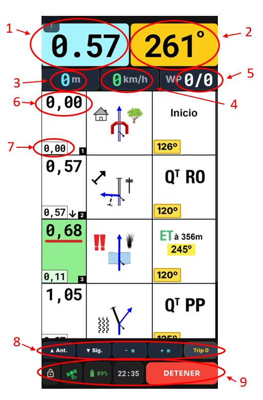
This image shows an example of how a digital roadbook looks in a navigation app (Rutas con Roadbook), an increasingly common tool on 4x4 and motorbike routes, off-road navigation and rally-style events.
The screen is split into three main areas:
Top
At the top we find the main navigation information. Here you see the total distance (1), showing the distance covered since the start. Next to it is the CAP or heading (2), in degrees, which marks the direction you're heading at each moment, especially useful when there are few visual references on the ground.
There's also a second odometer for the partial distance (3). This counter can be reset at any time, which is especially handy with double tulips or when you need to fine-tune your navigation. This area also shows the speedometer (4) in km/h, so you can keep an eye on your speed during the route, and the waypoint counter (5), which shows how many points you've completed out of the route total.
Middle
In the middle of the screen is the roadbook, laid out in rows split into three clearly separate columns:
- First column: shows the total distance (6) from the start of the route and the distance from the previous tulip (7). When these values have a green background, the next instruction is less than 300 metres away, warning you of an upcoming manoeuvre.
- Second column: shows the drawing of the junction, along with any hazard warnings or relevant terrain notes.
- Third column: extra information, such as PP (waypoint), QtPP (number of waypoints) or special instructions like double tulips, for example "ET à 300 m 165º", which indicate a change of direction at a specific distance.
Bottom
At the bottom of the screen are the quick navigation controls, which let you add or subtract distance in 0.01 km steps, move forward or back between tulips and reset the partial counter (Trip 2) when needed (8).
This area also includes navigation support information and functions, such as the screen lock button to avoid accidental taps, the GPS signal quality indicator, the device battery level and the button to stop navigating. All of these let you check at any time that the app is working properly and ensure reliable navigation throughout the route (9).
To see the roadbook better, this bottom bar can be hidden, leaving more room on screen and making the tulips and navigation instructions easier to read.
In this way, the app combines ease of use, precision and safety, giving you comfortable navigation on 4x4 routes, motorbike rides or any roadbook-based off-road navigation activity.
Types of roadbook
Standard (tulips only) or with headings (CAP): two ways to navigate the same route.